Stavropol Krai
| Stavropol Krai (English) Ставропольский край (Russian) |
|
|---|---|
| - Krai - | |
.svg.png) |
|
 Coat of arms of Stavropol Krai |
 Flag of Stavropol Krai |
| Anthem | none |
| Political status | |
| Country | Russia |
| Political status | Krai |
| Federal district | North Caucasian[1] |
| Economic region | North Caucasus[2] |
| Administrative center | Stavropol |
| Official language | Russian[3] |
| Statistics | |
| Population (2002 Census)[4] | 2,735,139 inhabitants |
| - Rank within Russia | 16th |
| - Urban[4] | 56.0% |
| - Rural[4] | 44.0% |
| - Density | 41.13 /km2 (106.5 /sq mi)[5] |
| Area (as of the 2002 Census)[6] | 66,500 km2 (25,675.8 sq mi) |
| - Rank within Russia | 45th |
| Established | January 10, 1934 |
| License plates | 26 |
| ISO 3166-2:RU | RU-STA |
| Time zone | MSK/MSD (UTC+3/+4) |
| Government (as of April 2009) | |
| Governor[7] | Valery Gayevsky[8] |
| Legislature | State Duma[7] |
| Charter | Charter (Basic Law) of Stavropol Krai |
| Official website | |
| http://www.stavkray.ru/ | |
Stavropol Krai (Russian: Ставропо́льский край, Stavropolsky kray) is a federal subject of Russia (a krai). Its administrative center is the city of Stavropol.
Contents |
Geography
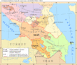
Stavropol Krai encompasses the central part of the Fore-Caucasus and most of the Northern slopes of Caucasus Major. It borders with Rostov Oblast, Krasnodar Krai, Republic of Kalmykia, Republic of Dagestan, Chechen Republic, North Ossetia-Alania, Kabardino-Balkar Republic, and Karachay-Cherkess Republic.
Stavropol is traversed by the northeasterly line of equal latitude and longitude.
Demographics
Population: 2,735,139 (2002 Census); 2,410,379 (1989 Census). The population of Stavropol Krai is concentrated in the Kuban River and Kuma River drainage basin, which used to be traditional Cossack land (see History of Cossacks). The Kuban Cossacks are now generally considered to be ethnic Russians, even though they are still an important minority in their own right in this area. Other notable ethnic groups include the Armenians (mostly Christian Hamsheni) who have been settling here since at least the 18th century.
Ethnic groups: The 2002 Census counted thirty-three ethnic groups of more than two thousand persons each, making this federal subject one of the most multicultural in Russia. The inhabitants identified themselves as belonging to more than 140 different ethnic groups, as shown in the following table:
| Population | Ethnicity | Percentage of total population |
|---|---|---|
| 2,231,759 | Russians | 81.6% |
| 149,249 | Armenians | 5.46% |
| 45,892 | Ukrainians | 1.68% |
| 40,218 | Dargins | 1.47% |
| 34,078 | Greeks | 1.25% |
| 20,680 | Nogais | 0.76% |
| 19,094 | Roma people | 1.47% |
| 15,146 | Karachay | 0.55% |
| 15,069 | Azeris | 0.55% |
| 13,937 | Turkmens | 0.51% |
| 13,208 | Chechens | 0.50% |
| 12,988 | Tatars | 0.5% |
| 8,047 | Germans | 0.28% |
| 7,772 | Ossetians | 0.26% |
| 7,484 | Turks | 0.26% |
| 5,744 | Kumyks | 0.22% |
| 3,902 | Kazakhs | 0.2% |
| 3,300 | Abazin | 0.17% |
A further 0.26% of the inhabitants declined to state their nationality on the census questionnaire.[9]
Vital Statistics for 2007: Source
- Birth Rate: 11.22 per 1,000
- Death Rate: 13.32 per 1,000
- Net Immigration: +3.5 per 1,000
- NGR: -0.21% per Year
- PGR: +0.14% per Year
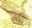
Administrative divisions
Agriculture
Irrigated agriculture is well developed in the region. As of the beginning of 2001, Stavropol Krai had 3361 km of irrigation canals, of which 959 km were lined (i.e. had concrete or stone walls, rather than merely soil walls, to reduce the loss of water).[10]
Among the major irrigation canals are:[10]
- Nevinnomyssk Canal (Невинномысский канал), the trunk of the Kuban-Yegorlyk Irrigation System.
- The Great Stavropol Canal (Большой Ставропольский канал), transporting water from the Kuban River eastward across the entire krai.
- The Terek-Kuma Canal and Kuma-Manych Canal, transporting water from the Terek River via the Kuma River to the East Manych River.
See also
- North Caucasus Krai
Notes
- ↑ Президент Российской Федерации. Указ №849 от 13 мая 2000 г. «О полномочном представителе Президента Российской Федерации в федеральном округе». Вступил в силу 13 мая 2000 г. Опубликован: "Собрание законодательства РФ", №20, ст. 2112, 15 мая 2000 г. (President of the Russian Federation. Decree #849 of May 13, 2000 On the Plenipotentiary Representative of the President of the Russian Federation in a Federal District. Effective as of May 13, 2000).
- ↑ Госстандарт Российской Федерации. №ОК 024-95 27 декабря 1995 г. «Общероссийский классификатор экономических регионов. 2. Экономические районы», в ред. Изменения №5/2001 ОКЭР. (Gosstandart of the Russian Federation. #OK 024-95 December 27, 1995 Russian Classification of Economic Regions. 2. Economic Regions, as amended by the Amendment #5/2001 OKER. ).
- ↑ According to Article 68.1 of the Constitution of Russia, Russian is the official language on the whole territory of the Russian Federation. Article 68.2 further stipulates that only the republics have the right to establish official languages other than Russian.
- ↑ 4.0 4.1 4.2 Федеральная служба государственной статистики (Federal State Statistics Service) (2004-05-21). "Численность населения России, субъектов Российской Федерации в составе федеральных округов, районов, городских поселений, сельских населённых пунктов – районных центров и сельских населённых пунктов с населением 3 тысячи и более человек (Population of Russia, its federal districts, federal subjects, districts, urban localities, rural localities—administrative centers, and rural localities with population of over 3,000)" (in Russian). Всероссийская перепись населения 2002 года (All-Russia Population Census of 2002). Federal State Statistics Service. http://perepis2002.ru/ct/html/TOM_01_04_1.htm. Retrieved 2010-03-01.
- ↑ The value of density was calculated automatically by dividing the 2002 Census population by the area specified in the infobox. Please note that this value may not be accurate as the area specified in the infobox is not necessarily reported for the same year as the Census (2002).
- ↑ Федеральная служба государственной статистики (Federal State Statistics Service) (2004-05-21). "Территория, число районов, населённых пунктов и сельских администраций по субъектам Российской Федерации (Territory, Number of Districts, Inhabited Localities, and Rural Administration by Federal Subjects of the Russian Federation)" (in Russian). Всероссийская перепись населения 2002 года (All-Russia Population Census of 2002). Federal State Statistics Service. http://perepis2002.ru/ct/html/TOM_01_03.htm. Retrieved 2008-10-17.
- ↑ 7.0 7.1 Charter, Article 8
- ↑ Official website of the Governor of Stavropol Krai. Biography of Valery Veniaminovich Gayevsky (Russian)
- ↑ (XLS) National Composition of Population for Regions of the Russian Federation. 2002 Russian All-Population Census. 2002. http://www.perepis2002.ru/ct/doc/English/4-2.xls. Retrieved 2006-07-20.
- ↑ 10.0 10.1 Общая информация О водных ресурсах края (General information about the water resources of the krai), from the regional government site. (Russian)
References
- Государственная Дума Ставропольского края. №6-кз 12 октября 1994 г. «Устав (основной закон) Ставропольского края», в ред. Закона №34-кз от 10 июня 2008 г. (State Duma of Stavropol Krai. #6-kz October 12, 1994 Charter (Basic Law) of Stavropol Krai, as amended by the Law #34-kz of June 10, 2008. ).
External links
- (English) News and events of Stavropol Krai
|
||||||||||||